


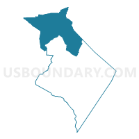
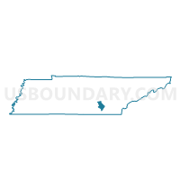
2 Cagle Voting District, Sequatchie County, Tennessee
About
Outline

Summary
| Unique Area Identifier | 669508 |
| Name | 2 Cagle Voting District |
| County | Sequatchie County |
| State | Tennessee |
| Area (square miles) | 65.81 |
| Land Area (square miles) | 65.81 |
| Water Area (square miles) | 0.00 |
| % of Land Area | 100.00 |
| % of Water Area | 0.00 |
| Latitude of the Internal Point | 35.49011240 |
| Longtitude of the Internal Point | -85.47000680 |
Maps

Graphs
Select a template below for downloading or customizing gragh for 2 Cagle Voting District, Sequatchie County, Tennessee


Neighbors
Neighoring Voting District (by Name) Neighboring Voting District on the Map
- 08-2 Irving College School Voting District, Warren County, TN
- 1-1 Dill Voting District, Bledsoe County, TN
- 2 Fredonia Voting District, Sequatchie County, TN
- 3 Electric Co-op Voting District, Sequatchie County, TN
- Beersheba Voting District, Grundy County, TN
- Collins Voting District, Grundy County, TN
- Piney Fire Hall Voting District, Van Buren County, TN
- White Hill Community Cntr. Voting District, Van Buren County, TN
Top 10 Neighboring County Subdivision (by Population) Neighboring County Subdivision on the Map
- District 1, Grundy County, TN (4,573)
- District 8, Warren County, TN (3,216)
- District 1, Bledsoe County, TN (2,945)
- District 2, Sequatchie County, TN (2,112)
- District 3, Sequatchie County, TN (1,777)
- District 4, Van Buren County, TN (1,135)
Top 10 Neighboring Place (by Population) Neighboring Place on the Map
Top 10 Neighboring Unified School District (by Population) Neighboring Unified School District on the Map
- Warren County School District, TN (39,839)
- Sequatchie County School District, TN (14,112)
- Grundy County School District, TN (13,703)
- Bledsoe County School District, TN (12,876)
- Van Buren County School District, TN (5,548)
Top 10 Neighboring State Legislative District Lower Chamber (by Population) Neighboring State Legislative District Lower Chamber on the Map
- State House District 25, TN (68,929)
- State House District 37, TN (61,600)
- State House District 43, TN (58,799)
Top 10 Neighboring State Legislative District Upper Chamber (by Population) Neighboring State Legislative District Upper Chamber on the Map
Top 10 Neighboring 111th Congressional District (by Population) Neighboring 111th Congressional District on the Map
Top 10 Neighboring Census Tract (by Population) Neighboring Census Tract on the Map
- Census Tract 601.01, Sequatchie County, TN (8,037)
- Census Tract 9532, Bledsoe County, TN (4,360)
- Census Tract 9552, Grundy County, TN (4,075)
- Census Tract 9550, Grundy County, TN (2,770)
- Census Tract 9250, Van Buren County, TN (2,367)
- Census Tract 601.02, Sequatchie County, TN (2,174)
- Census Tract 9309, Warren County, TN (1,806)